
I tracked down the etymology of all Sapporo Municipal Subway station names and Sapporo Streetcar stop names, then localized them into plausible-sounding (American) English names.
If the place name derives from the indigenous language Ainu, I translated the meaning in Ainu, instead of the surface realization in kanji.
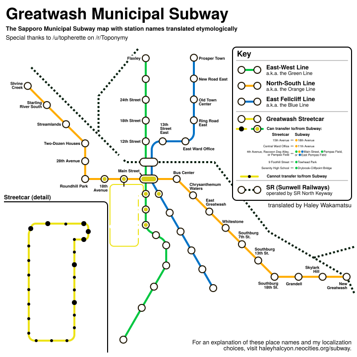
This is intended to be in the same alternate universe as u/topherette's anglicized map of the Prefectures of Sunwell and its major cities. See the map here on r/Toponymy! Differences from the u/topherette map are as follows:
My findings, translation decisions, and reasonings can be found in a massive table below.
As context, Sapporo is divided into 10 wards (区, "ku"). The subway spans 8 of them, while the streetcar is fully within the bounds of one. (Here, the "(T)" means "Terminus".)
As a reference to New York City, and for no actual good reason, I am calling the wards "boroughs".
| Ward name | Reading | Origin (minus the 区) | Etymology | My English localization | Reasoning | Served by... |
|---|---|---|---|---|---|---|
| 中央区 | chuuou ku | Japanese | "Center ward". | Central Borough | Literal. | SC (all); N06-N10; T05-T10; H07-H11. |
| 北区 | kita ku | Japanese | "North ward". | North Borough | Literal. | N01(T)-N05. H crosses it (H06-H07) but does not stop inside it. |
| 東区 | higashi ku | Japanese | "East ward". | East Borough | Literal. | H01(T)-H06. |
| 白石区 | shiroishi ku | Japanese | "White stone ward". cf. Shiroishi station (Tozai line). | Whitestone Borough | Consistent with my name for Shiroishi. | T11-T16. |
| 豊平区 | toyohira ku | Ainu | From tuye pira "fallen cliff". cf. Toyohira Koen station (Toho line). | Fellcliff Borough | Consistent with my name for Toyohira Koen. | N11-N13; H10-H14(T). |
| 南区 | minami ku | Japanese | "South ward". | South Borough | Literal. | N14-N16(T). |
| 西区 | nishi ku | Japanese | "West ward". | West Borough | Literal. | T01(T)-T04. |
| 厚別区 | atsubetsu ku | Ainu | Named after the Atsubetsu river, also known as "Ashiribetsu" upstream in Kiyota ward. The last element is "pet" meaning "river". The first element is uncertain; The city officially lists three possibilities, which are "hasi" (Viburnum sargentii shrub), "at" (Ulmus laciniata tree, the fiber in whose bark was extracted for clothes), and a second "at" (rife for fishing). | Shawbourne Borough | Calque using Old English-based lexemes: "shaw" for "wood; thicket" and "bourne" for "river". Thanks to this Wikipedia article. | T17-T19(T). |
| 手稲区 | teine ku | Ainu | Either teyne-nitat "wetland" or teyne-i "wet place", which it was before colonization and urbanization. | Fenwick Borough | Descriptive name using Old English-based lexemes: "fen" for "mud, marsh" and "-wick" for "place, settlement". As with many other "-wick" names like "Warwick", I prescribe pronouncing it with a silent W. | None |
| 清田区 | kiyota ku | Japanese | From 清 "pure, clear" and 田 "rice paddy". | Clearfield Borough | Literal. | None |
| ID | Name | Reading | Origin | Etymology | English calque | Reasoning |
| N** | 南北線 | nam-boku sen | Japanese | North-South Line a.k.a. "Green Line" | Direct | |
| N01 | 麻生駅 | asa-bu eki | Japanese | 麻 (flax) and 生 (to grow). Same name exists in Tokyo but that one is pronounced "Azabu" | Flaxley | Existing place name meaning "flax field" |
| N02 | 北34条駅 | kita sanjū-yon jō eki | Japanese | 北 (north), number, 条 [indicates the block number going north-south] | 34th Street | NYC reference. (NB that NYC's avenues go East, while Sapporo's "chome" goes both ways, only West in station names.) |
| N03 | 北24条駅 | kita nijū-yon jō eki | Japanese | cf. 北34条駅 | 24th Street | |
| N04 | 北18条駅 | kita jū-hachi jō eki | Japanese | cf. 北34条駅 | 18th Street | |
| N05 | 北12条駅 | kita jū-ni jō eki | Japanese | cf. 北34条駅 | 12th Street | |
| N06 | さっぽろ駅 | [sapporo] eki | Ainu | "Sat poro pet": dry great river | Greatwash | Translation "Great Wash" by u/topherette on r/Toponymy, space removed for aesthetic reasons. |
| N07 | 大通駅 | ō-dōri eki | Japanese | 大通 means "main street" or "boulevard" | Central Park | Ōdōri Park splits the city down the middle with a long stretch of public green space. Also a NYC reference. |
| N08 | すすきの駅 | [susukino] eki | Japanese | すすきの is variant transcription of 薄野: 薄 (pampas grass) and 野 (field) | Pampas Field | Direct |
| N09 | 中島公園駅 | naka-jima-kō-en eki | Japanese | 中島 refers to a river island, 公園 means park; I can't explain the inconsistency between Nakajima and Nakanoshima 2 stations down, as they mean the same thing. | Towhead Park | "Towhead" is a US regional term for a river island |
| N10 | 幌平橋駅 | horo-hira-bashi eki | blend | 橋 (bridge) between 札幌 and 平岸 | Drybrook-Cliffpoint Bridge | |
| N11 | 中の島駅 | naka-[no]-shima eki | Japanese | 中の島 also refers to a river island; I can't explain the inconsistency between Naka-no-shima and Nakajima 2 stations up, as they mean the same thing. | Towhead | cf. 中島公園 |
| N12 | 平岸駅 | hira-gishi eki | Ainu | "Pira kes": edge of the cliff | Cliffpoint | |
| N13 | 南平岸駅 | minami hira-gishi eki | blend | 南 (south) of 平岸 (of Ainu origin, see above) | South Cliffpoint | |
| N14 | 澄川駅 | sumi-kawa eki | Japanese | 澄 (clear, see-through, pure) and 川 (river). Specifically refers to the 精進川 (Shōjin River) nearby. | Clearwater | Direct |
| N15 | 自衛隊前駅 | ji-ei-tai mae eki | Japanese | 前 (in front) of the 自衛隊 (Self Defense Force). There is an SDF station nearby. | Defense/Defence Depot | |
| N16 | 真駒内駅 | ma-koma-nai eki | Ainu | "Mak oma nai": river behind one's back (the reason why the river is called that is hotly debated) | Back Creek | |
| T** | 東西線 | tō-zai sen | Japanese | East-West Line a.k.a. "Orange Line" | ||
| T01 | 宮の沢駅 | miya-[no]-sawa eki | Japanese | "shrine + small river", place named after what would later become 上手稲神社 (Kami-Teine Shrine) | Shrine Creek | |
| T02 | 発寒南駅 | has-samu minami eki | blend | 南 (south) of 発寒 (of Ainu origin, specific origin unclear, one competing etymology claims “hacham pet”: starling river) | Starling River South | |
| T03 | 琴似駅 | koto-ni eki | Ainu | System of various small rivers was called "Kotoni" in Ainu | Streamlands | |
| T04 | 二十四軒駅 | ni-jū-yon-ken eki | Japanese | 24 houses. Derives from an event when 50 families were relocated in small groups from present day 山鼻 (Yamahana) area. There is also a 八軒 (hakken, eight houses) elsewhere | Two-Dozen Houses | the opportunity for "24 = 2 dozen" was too juicy to resist. |
| T05 | 西28丁目駅 | nishi nijū-hat-chō-me eki | Japanese | 西 (west), number, 丁目 [indicates the block number going east-west] | 28th Avenue | NYC reference. (NB that NYC's avenues go East, while Sapporo's "chome" goes both ways, and only West in station names.) |
| T06 | 円山公園駅 | maru-yama kō-en eki | Japanese | 公園 (park) near the 円山 (round mountain). Said mountain was called Moiwa (Ainu: small mountain) but present Mt. Moiwa is elsewhere to the southeast and significantly taller. | Roundhill Park | |
| T07 | 西18丁目駅 | nishi jū-hat-chō-me eki | Japanese | cf. 西28丁目駅 | 18th Avenue | cf. 西28丁目 |
| T08 | 西11丁目駅 | nishi jū-it-chō-me eki | Japanese | cf. 西28丁目駅 | 11th Avenue | cf. 西28丁目 |
| T09 | 大通駅 | Japanese | 大通 means "main street" or "boulevard" | Main Street | Ōdōri Park splits the city down the middle with a long stretch of public green space. Also a NYC reference. | |
| T10 | バスセンター前駅 | [basusentā] mae eki | Japanese | 前 (in front) of the バスセンター (bus center) | Bus Center | Direct minus the "mae" |
| T11 | 菊水駅 | kiku-sui eki | Japanese | 菊 (chrysanthemum) referring to 菊亭 脩季 (Kikutei Yukisue or Nagasue), the politician who opened a major farm in the area + 水 (water) referring to the Toyohira river | Chrysanthemum Waters | Direct |
| T12 | 東札幌駅 | higashi sap-poro eki | blend | 東 (east) of 札幌 (Sapporo, cf. Sapporo station) | East Greatwash | |
| T13 | 白石駅 | shiro-ishi eki | Japanese | white + stone. inherited from 白石, place name in modern-day Miyagi | Whitestone | |
| T14 | 南郷7丁目駅 | nan-gō nana-chō-me eki | Japanese | 南郷 (south + village/township) used to refer to anywhere south of 白石本道 (main street of Shiroishi) | Southburg 7th Street | Using "-burg" instead of "-ville" was an arbitrary decision |
| T15 | 南郷13丁目駅 | nan-gō jū-san-chō-me eki | Japanese | cf. 南郷7丁目駅 | Southburg 13th Street | cf. 南郷7丁目 |
| T16 | 南郷18丁目駅 | nan-gō jū-hat-chō-me eki | Japanese | cf. 南郷7丁目駅 | Southburg 18th Street | cf. 南郷7丁目 |
| T17 | 大谷地駅 | ō-ya-chi eki | Japanese | large valley/dell | Grandell | coined from grand + dell |
| T18 | ひばりが丘駅 | [hibari ga]-oka eki | Japanese | named after a local housing area called ひばりが丘団地 (hibarigaoka danchi) meaning "Skylark Hill Housing Complex" | Skylark Hill | Direct |
| T19 | 新さっぽろ駅 | shin-[sapporo] eki | blend | 新 (new) city center of さっぽろ (Sapporo, cf. Sapporo station) | New Greatwash | |
| H** | 東豊線 | tō-hō sen | blend | 東 (east) of 豊平 from Ainu "tuye pira", fallen cliff | East Fellcliff Line a.k.a. "Blue Line" | |
| H01 | 栄町駅 | sakae-machi eki | Japanese | literally "prosperous town", renamed 1955 wishfully | Prosper Town | |
| H02 | 新道東駅 | shin-dō higashi eki | Japanese | 東 (east) of the 札幌新道 ("Sapporo Shindō", Sapporo New Road), a bypass highway | New Road East | |
| H03 | 元町駅 | moto-machi eki | Japanese | literally "origin/root/center of the town". Motomachi ceased to be an address in 1981, before it was revived for the subway station name in 1988 | Old Town Center/Centre | "Old" to reference its defunction as an address even before the subway station was named. |
| H04 | 環状通東駅 | kan-jō-dōri higashi eki | Japanese | "ring-shaped road east" | Ring Road East | Unfinished London's video about the Ring Roads has left an impression on me |
| H05 | 東区役所前駅 | higashi-ku-yaku-sho mae eki | Japanese | 前 (in front) of the 区役所 (ward's town hall) of 東区 (East Ward) | East Ward Office | Direct minus the "mae" |
| H06 | 北13条東駅 | kita jū-san-jō higashi eki | Japanese | 東 (east) part of this street: 北 (north), number, 条 [indicates the block number going north-south] | 13th Street East | cf. 北34条 |
| H07 | さっぽろ駅 | Ainu | "Sat poro pet": dry great river | Greatwash |
Translation by u/topherette on r/Toponymy
|
|
| H08 | 大通駅 | Japanese | 大通 means "main street" or "boulevard" | Central Park | Ōdōri Park splits the city down the middle with a long stretch of public green space. Also a NYC reference. | |
| H09 | 豊水すすきの駅 | hō-sui [susukino] eki | Blend? | named after local primary school that closed in 2004, 豊 probably from 豊平, 水 means water. for "susukino" see すすきの駅 | East Pampas Field | Descriptive name avoiding reference to a defunct school with a complicated etymology |
| H10 | 学園前駅 | gaku-en mae eki | Japanese | 前 (in front) of the 学園 (academy). Serves at least 5 different schools and universities run by Hokkai Gakuen. | Academy | Direct minus the "mae" |
| H11 | 豊平公園駅 | toyo-hira kō-en eki | blend | 豊平 from Ainu "tuye pira", fallen cliff + 公園 park | Fellcliff Park | |
| H12 | 美園駅 | mi-sono eki | Japanese | beautiful + garden. references the numerous flower growers/farms in the area | Flowery Streets | |
| H13 | 月寒中央駅 | tsuki-samu chū-ō eki | blend | 中央 for "central". 月寒 (Tsukisamu) river either named after "cikisap", a fire-starting tool, or "cikisani", elm (whose wood is used for cikisap) | Elm Country Central | |
| H14 | 福住駅 | fuku-zumi eki | Japanese | probably named after a Shinto shrine on the block: 福住寺 (fuku-jū-ji), good luck/fortune + live/lodge + shrine/temple | Felicity | rare word meaning “happiness” or “good luck”, coming from Latin “felix” |
| SC** | 札幌市電 | sap-poro shi-den | Greatwash Streetcar a.k.a. "Southwest Loop" | |||
| SC01 | 西4丁目 | Japanese | cf. 西28丁目駅 | 4th Avenue | ||
| SC02 | 西8丁目 | Japanese | cf. 西28丁目駅 | 8th Avenue | ||
| SC03 | 中央区役所前 | Japanese | Central Ward Office | |||
| SC04 | 西15丁目 | Japanese | cf. 西28丁目駅 | 15th Avenue | ||
| SC05 | 西線6条 | Japanese | 西線 refers to the former "Western Line" of the streetcar system (now reduced to one looped line). Station lies on 南 (South) 6-jō. | West F Street | NYC reference: south streets get letters of the Alphabet, so "South 6" becomes "F Street" | |
| SC06 | 西線9条旭山公園通 | Japanese | Serves 旭山公園通 (Asahiyama [Morning Sun Mountain] Kōen [Park] Dōri [Street]), whose name I can't explain because no park by that name lies on that street, and Asahiyama Zoo lies way far in Asahikawa City | West I Street / Sunrise Mountain Park Road | Double-barrelled station name exactly as long and unwieldy as the Japanese original. | |
| SC07 | 西線11条 | Japanese | West K Street | |||
| SC08 | 西線14条 | Japanese | West N street | |||
| SC09 | 西線16条 | Japanese | West P Street | |||
| SC10 | ロープウェイ入口 | Japanese | 入口 (Entrance) to the ロープウェイ (ropeway), specifically the one on Mt. Moiwa. The native Ainu name was "Inkaruspe" (place frequently climbed for lookout). For the origin of "Moiwa" cf. 円山公園 (on Tozai line). | Little Hill Ropeway | Native American-vibes calque of Moiwa | |
| SC11 | 電車事業所前 | Japanese | Rail Office | |||
| SC12 | 中央図書館前 | Japanese | Central Library | |||
| SC13 | 石山通 | Japanese | Quarry Street | |||
| SC14 | 東屯田通 | Japanese | 屯田兵 (tonden hei) were "field-encampment soldiers" who were stationed by the Japanese military to "settle" Hokkaido and Sakhalin. (cf. Wikipedia) | East Pioneer Street | ||
| SC15 | 幌南小学校前 | kō-nan shō-gak-kō mae | blend | Serves 幌南小学校, where 幌 is short for Sapporo and 南 means South | South Greatwash Elementary School | |
| SC16 | 山鼻19条 | Japanese | Named after 山鼻 (Yamahana) village. Named because it was the はな (edge) of the 山 (mountain), specifically Mt. Moiwa. 鼻 meaning "nose" is folk etymology. Ainu native name was "Yuk Nikuri" (grove where the deer live) | 19 Foothill Street | A foothill is a gradual increase in elevation at the base of a mountain range. | |
| SC17 | 静修学園前 | Japanese | Named after the local 札幌静修高等学校 (Sapporo Seishū High School). 静修 means "to cleanse the mind and body; to meditate at a retreat" | Serenity High School | No direct equivalent for 静修; chose a vaguely thematic word. | |
| SC18 | 行啓通 | gyō-kei dōri | Japanese | References street name. 行啓 means a visit by the Japanese Imperial Family. Street named in reference to the Imperial Family visiting Sapporo three different times. | Imperial Street | |
| SC19 | 中島公園通 | Japanese | cf. Nakajima Koen on the Tozai line. Previously known as 狐小路 (fox alley) but this parallel with Tanuki Koji didn't survive long. | Towhead Park Street | ||
| SC20 | 山鼻9条 | Japanese | cf. Yamahana 19-jo | 9 Foothill Street | ||
| SC21 | 東本願寺前 | Japanese | Named after the nearby 真宗大谷派札幌別院, a shrine of the Ōtani-ha sect of Jōdo Shinshū a.k.a. True Pure Land Buddhism. | True Pure Land Shrine | Descriptive but not literal. | |
| SC22 | 資生館小学校前 | Japanese | Shiseikan is an old primary education org. The same "Shisei" as in the cosmetics company "Shiseido", derived from "萬物資生" (banbutsu shisei) from the I Ching | Nascence Elementary School | 萬物資生 was translated as "the ten-thousand things coming into life", so the word "nascence" was chosen to translate the "shisei" part. | |
| SC23 | すすきの | [susukino] eki | Japanese | すすきの is variant transcription of 薄野: 薄 (pampas grass) and 野 (field). cf. Susukino on the Namboku Line. | Pampas Field | Direct |
| SC24 | 狸小路 | tanuki kouji | Japanese | 狸 (tanuki, raccoon dog) and 小路 (alley) | Raccoon Dog Alley | Direct |


